Finally replaced my old Garmin Edge 305 which wouldn't hold a charge for more than 90 minutes. For about $85, got a refurbished unit which seems to working well. We'll see how long this lasts...
Here are a few recent rides mapped out on Garmin Connect:
Monday, September 13, 2010
Tuesday, May 12, 2009
Mt. Wilson MTB Ride
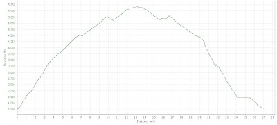
After failing to reach the top of Mt. Wilson last month, I gave it another try on Saturday via a more direct route with less climbing. Along with Mike and Miles, started at the bottom of Chaney Trail at about 1,500 ft and made it to the antennas at 5,600+ ft.
Here's a Google Map with a few data errors:
View Larger Map
Here's an elevation graph:
A few photos from the trail:

A view of the antennas in the distance from the saddle near Inspiration Point.

Mike (with his new Blur LT) and Miles in front a rock-slide at the tunnel.

A view of the antennas from below.

An encouraging sign on the far side of the tunnel.
The ride was marred by a crash towards the end. Miles went over the bars in a rocky section near the bottom of the Merrill single-track and landed on his head. After the incident, we skipped the Sunset Peak single-track opting instead for the smoother Lower Merrill Trail. He went to Urgent Care the next day and got X-rays which luckily confirmed that nothing was broken. Gnarly.
Here's a Google Map with a few data errors:
View Larger Map
Here's an elevation graph:

A few photos from the trail:

A view of the antennas in the distance from the saddle near Inspiration Point.

Mike (with his new Blur LT) and Miles in front a rock-slide at the tunnel.

A view of the antennas from below.

An encouraging sign on the far side of the tunnel.
The ride was marred by a crash towards the end. Miles went over the bars in a rocky section near the bottom of the Merrill single-track and landed on his head. After the incident, we skipped the Sunset Peak single-track opting instead for the smoother Lower Merrill Trail. He went to Urgent Care the next day and got X-rays which luckily confirmed that nothing was broken. Gnarly.
Saturday, March 21, 2009
Friday MTB Ride
Took the day off work yesterday and squeezed in a ride.
Heading up Sullivan Canyon, ran into two Gas Company workers. The latest is that they'll be making minor repairs to the exposed gas line through the spring. The big plow job to create truck access to the pipe up the canyon is scheduled for summer. That should be the end of what's been a fun local trail.

Here are some pics from the ride. The trails are in great shape and everything is quite green. Rusty Car single-track:


Backbone Trail:


What happens when you don't pay attention:

2009 Tour of California Race
A few belated shots from the second-to-last stage of the Amgen Tour of California road race finishing up at the Rose Bowl in Pasadena.
The peloton:

Mavic neutral support in action:

Frank Schleck looking over his shoulder:

Astana riders protecting Levi:

The peloton:

Mavic neutral support in action:

Frank Schleck looking over his shoulder:

Astana riders protecting Levi:

Monday, February 23, 2009
Mt. Lowe MTB Ride
After a lengthy hiatus, I have some worthy material to share.
Rode the San Gabriels on Saturday with Brett and Miles before checking out the Tour of California finishing up at the Rose Bowl. The route went up Brown Mtn, up the Millard single-track, then up Mt. Lowe road. Going down, we hit the middle Sam Merrill Trail, then the Sunset Peak Trail.
Here's a MotionBased Map:

Here's an elevation graphic:

Here are pics from the ride. Heading up the Brown Mtn fire-road.

Hitting snow at about 3,750 feet. From this point on, there was a lot of walking.


At the drop-in of the middle Sam Merrill trail.


Looking out over Echo Mtn and the Mt. Lowe road.

Rode the San Gabriels on Saturday with Brett and Miles before checking out the Tour of California finishing up at the Rose Bowl. The route went up Brown Mtn, up the Millard single-track, then up Mt. Lowe road. Going down, we hit the middle Sam Merrill Trail, then the Sunset Peak Trail.
Here's a MotionBased Map:
Here's an elevation graphic:

Here are pics from the ride. Heading up the Brown Mtn fire-road.

Hitting snow at about 3,750 feet. From this point on, there was a lot of walking.


At the drop-in of the middle Sam Merrill trail.


Looking out over Echo Mtn and the Mt. Lowe road.

Sunday, November 16, 2008
Worst. Website. Ever.
My vote for the weather-related website with the poorest information? AirNow.gov. Check out their air quality maps for this Saturday and Sunday...


Looks OK except for a few pockets, right? Why is it then that when I walk outside, I can smell acrid smoke and see ash? Oh yeah, the wildfires.
Here's one of the big problems, the Sylmar fire:
View Larger Map
Photos courtesy of the LA Times:


Looks OK except for a few pockets, right? Why is it then that when I walk outside, I can smell acrid smoke and see ash? Oh yeah, the wildfires.
Here's one of the big problems, the Sylmar fire:
View Larger Map
Photos courtesy of the LA Times:


Sunday, November 09, 2008
Halloween Night Ride
Broke out the headlight for a Halloween night ride in the Santa Monicas a few weeks ago. Participants included Mike, Miles, Nor, Andrew, Brett and Jinn. Despite a few light issues, it was awesome -- warm temps and very little trail dust.
Here are a few photos from the road and trail:


Here's a link to data on MotionBased: Sullivan Canyon; Rusty Car; Backbone Trail
A map of the ride route:
View Larger Map
Here are a few photos from the road and trail:


Here's a link to data on MotionBased: Sullivan Canyon; Rusty Car; Backbone Trail
A map of the ride route:
View Larger Map
Tuesday, October 28, 2008
Recent Road/Cyclocross Rides
Sunday: San Vicente; PCH; Las Flores Cyn; Stunt Rd; Mulholland Hwy; Kanan Rd; Latigo Cyn; PCH; Montana
View Larger Map
A few cell phone pics from the road. Las Flores Canyon Road right before it gets steep:

Rambla Pacifica with the towers in the background:

The top of Schueren and Stunt Road at 2,300 ft:

Saturday: Westridge Fire-Road; Dirt Mulholland; Mulholland Hwy; Old Topanga; Topanga Cyn; PCH; San Vicente
View Larger Map
Last Sunday: San Vicente; PCH; Las Flores Cyn; Rambla Pacifica; Stunt Rd; Mulholland Hwy; Old Topanga Rd; Topanga Cyn; PCH; Montana
View Larger Map
Last Saturday: San Vicente; PCH; Topanga Cyn; Mulholland Hwy; Kanan Rd; PCH; Montana
View Larger Map
Came across a small fire on PCH on the way home. Here are cell phone pics:


View Larger Map
A few cell phone pics from the road. Las Flores Canyon Road right before it gets steep:

Rambla Pacifica with the towers in the background:

The top of Schueren and Stunt Road at 2,300 ft:

Saturday: Westridge Fire-Road; Dirt Mulholland; Mulholland Hwy; Old Topanga; Topanga Cyn; PCH; San Vicente
View Larger Map
Last Sunday: San Vicente; PCH; Las Flores Cyn; Rambla Pacifica; Stunt Rd; Mulholland Hwy; Old Topanga Rd; Topanga Cyn; PCH; Montana
View Larger Map
Last Saturday: San Vicente; PCH; Topanga Cyn; Mulholland Hwy; Kanan Rd; PCH; Montana
View Larger Map
Came across a small fire on PCH on the way home. Here are cell phone pics:


Subscribe to:
Comments (Atom)